Blog

  • Prince Harry makes surprise visit to Ukraine in support of wounded troops : NPR

    Prince Harry makes surprise visit to Ukraine in support of wounded troops : NPR


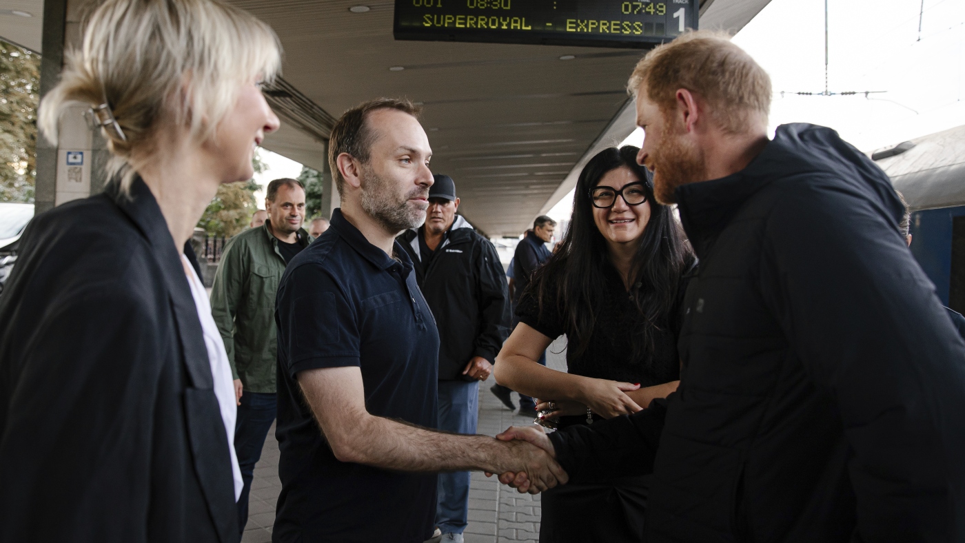
    Britain's Prince Harry, right, arrives at a railway station in Kyiv, Ukraine, on Friday, Sept. 12, 2025.

    Britain’s Prince Harry, right, arrives at a railway station in Kyiv, Ukraine, on Friday, Sept. 12, 2025.

    Railway of Ukraine Ukrzaliznytsia/AP


    hide caption

    toggle caption

    Railway of Ukraine Ukrzaliznytsia/AP

    LONDON — Britain’s Prince Harry has arrived in Ukraine for a surprise visit in support of wounded service members.

    Harry’s representatives confirmed they were in the capital, Kyiv, on Friday, though they declined to discuss the prince’s schedule for security reasons.

    This is the second time Harry has visited Ukraine since the start of Russia’s full scale invasion in 2022. He made a trip to the western city of Lviv in April.

    “We cannot stop the war but what we can do is do everything we can to help the recovery process,” Harry told the Guardian newspaper while on an overnight train to Kyiv.

    Harry, a British Army veteran who served in Afghanistan, is the founder of the Invictus Games, a Paralympic-style event designed to inspire military veterans around the world as they work to overcome battlefield injuries. Ukraine is bidding to host the games in 2029.

    The Archewell foundation set up by Harry and his wife Meghan announced this week that it had donated $500,000 to projects supporting injured children from Gaza and Ukraine. The money will be used to help the World Health Organization with medical evacuations and to fund work developing prosthetics for seriously injured young people.

    The Guardian said that Harry will visit the National Museum of the History of Ukraine in the Second World War, spend time with 200 veterans and meet Ukrainian Prime Minister Yulia Svyrydenko.

    His visit coincided with a trip to Ukraine by British Foreign Secretary Yvette Cooper, who announced a new set of U.K. sanctions targeting Russia’s oil revenues and military supplies.

    Cooper said the visit is a show of solidarity with Ukrainians facing intensified assault from Russia – including 6,500 drones and missiles in July, 10 times the level of a year ago.

    In this photo provided by the Railway of Ukraine Ukrzaliznytsia on Friday, Sept. 12, 2025, Britain's Prince Harry arrives at a central railway station in Kyiv.

    In this photo provided by the Railway of Ukraine Ukrzaliznytsia on Friday, Sept. 12, 2025, Britain’s Prince Harry arrives at a central railway station in Kyiv.

    Railway of Ukraine Ukrzaliznytsia/AP


    hide caption

    toggle caption

    Railway of Ukraine Ukrzaliznytsia/AP

    Harry’s appearance in Ukraine follows a four-day trip to the U.K., where he met his father, King Charles III, for the first time in 19 months. The meeting was seen as a first step in repairing frigid relations between Harry and other members of the royal family, which deteriorated after he and his wife, the former Meghan Markle, gave up royal duties and moved to California in 2020.

    Harry and his father last met in February 2024, when the prince flew to London after receiving news that Charles had been diagnosed with cancer. Harry spent about 45 minutes with Charles before the king flew to his Sandringham country estate to recuperate from his treatment.

    Prince Harry’s last trip to Ukraine included a visit to the Superhumans Center, an orthopedic clinic in Lviv that treats wounded military personnel and civilians. The center provides prosthetic limbs, reconstructive surgery and psychological help free of charge.

    Harry’s visit Friday come as Russia escalates its war against Ukraine.

    It is less than a week after Russia’s largest aerial attack on Ukraine since its all-out invasion began more than three years ago — an attack in which the main Ukrainian government building was hit. It also comes just days after numerous Russian drones entered the airspace of NATO member Poland — the country Harry traveled through to reach Ukraine.


    Source link

  • Prince Harry makes surprise visit to Ukraine in support of wounded troops : NPR

    Prince Harry makes surprise visit to Ukraine in support of wounded troops : NPR


    Britain's Prince Harry, right, arrives at a railway station in Kyiv, Ukraine, on Friday, Sept. 12, 2025.

    Britain’s Prince Harry, right, arrives at a railway station in Kyiv, Ukraine, on Friday, Sept. 12, 2025.

    Railway of Ukraine Ukrzaliznytsia/AP


    hide caption

    toggle caption

    Railway of Ukraine Ukrzaliznytsia/AP

    LONDON — Britain’s Prince Harry has arrived in Ukraine for a surprise visit in support of wounded service members.

    Harry’s representatives confirmed they were in the capital, Kyiv, on Friday, though they declined to discuss the prince’s schedule for security reasons.

    This is the second time Harry has visited Ukraine since the start of Russia’s full scale invasion in 2022. He made a trip to the western city of Lviv in April.

    “We cannot stop the war but what we can do is do everything we can to help the recovery process,” Harry told the Guardian newspaper while on an overnight train to Kyiv.

    Harry, a British Army veteran who served in Afghanistan, is the founder of the Invictus Games, a Paralympic-style event designed to inspire military veterans around the world as they work to overcome battlefield injuries. Ukraine is bidding to host the games in 2029.

    The Archewell foundation set up by Harry and his wife Meghan announced this week that it had donated $500,000 to projects supporting injured children from Gaza and Ukraine. The money will be used to help the World Health Organization with medical evacuations and to fund work developing prosthetics for seriously injured young people.

    The Guardian said that Harry will visit the National Museum of the History of Ukraine in the Second World War, spend time with 200 veterans and meet Ukrainian Prime Minister Yulia Svyrydenko.

    His visit coincided with a trip to Ukraine by British Foreign Secretary Yvette Cooper, who announced a new set of U.K. sanctions targeting Russia’s oil revenues and military supplies.

    Cooper said the visit is a show of solidarity with Ukrainians facing intensified assault from Russia – including 6,500 drones and missiles in July, 10 times the level of a year ago.

    In this photo provided by the Railway of Ukraine Ukrzaliznytsia on Friday, Sept. 12, 2025, Britain's Prince Harry arrives at a central railway station in Kyiv.

    In this photo provided by the Railway of Ukraine Ukrzaliznytsia on Friday, Sept. 12, 2025, Britain’s Prince Harry arrives at a central railway station in Kyiv.

    Railway of Ukraine Ukrzaliznytsia/AP


    hide caption

    toggle caption

    Railway of Ukraine Ukrzaliznytsia/AP

    Harry’s appearance in Ukraine follows a four-day trip to the U.K., where he met his father, King Charles III, for the first time in 19 months. The meeting was seen as a first step in repairing frigid relations between Harry and other members of the royal family, which deteriorated after he and his wife, the former Meghan Markle, gave up royal duties and moved to California in 2020.

    Harry and his father last met in February 2024, when the prince flew to London after receiving news that Charles had been diagnosed with cancer. Harry spent about 45 minutes with Charles before the king flew to his Sandringham country estate to recuperate from his treatment.

    Prince Harry’s last trip to Ukraine included a visit to the Superhumans Center, an orthopedic clinic in Lviv that treats wounded military personnel and civilians. The center provides prosthetic limbs, reconstructive surgery and psychological help free of charge.

    Harry’s visit Friday come as Russia escalates its war against Ukraine.

    It is less than a week after Russia’s largest aerial attack on Ukraine since its all-out invasion began more than three years ago — an attack in which the main Ukrainian government building was hit. It also comes just days after numerous Russian drones entered the airspace of NATO member Poland — the country Harry traveled through to reach Ukraine.


    Source link

  • Before and after satellite images show how Israel has destroyed Gaza City | Israel-Palestine conflict News

    Before and after satellite images show how Israel has destroyed Gaza City | Israel-Palestine conflict News


    Israel is demolishing Gaza City’s high-rise towers, flattening entire blocks that once housed thousands of people.

    The Palestinian Civil Defence said at least 50 multistorey buildings have been destroyed in recent weeks as Israeli forces press their assault on the city, all amid a wave of forced displacements.

    Some neighbourhoods have faced near-total destruction. In Gaza City’s Zeitoun area alone, more than 1,500 homes and buildings have been destroyed since early August, leaving parts of the district with no buildings left standing.

    INTERACTIVE - Gaza neighbourhoods map Israel destroy cms-1757589796
    [Al Jazeera]

    Israel forcing people to move south

    Reporting from Gaza City, Al Jazeera’s Hani Mahmoud said people are making their way from Gaza City to the southern and central areas of the Gaza Strip. However, some people have been coming back because they are unable to find a place to stay.

    The only routes south are Salah al-Din Street and the coastal al-Rashid Street. Salah al-Din is sealed off by snipers while movement along al-Rashid, crowded with displaced families in tents, is deadly.

    There is no safe place in Gaza, including the “humanitarian zone” designated by Israel in the southern coastal area of al-Mawasi.

    INTERACTIVE - Israel pushing people south-1755592754
    Israel is deliberately pushing people south as part of its invasion of northern Gaza [Al Jazeera]

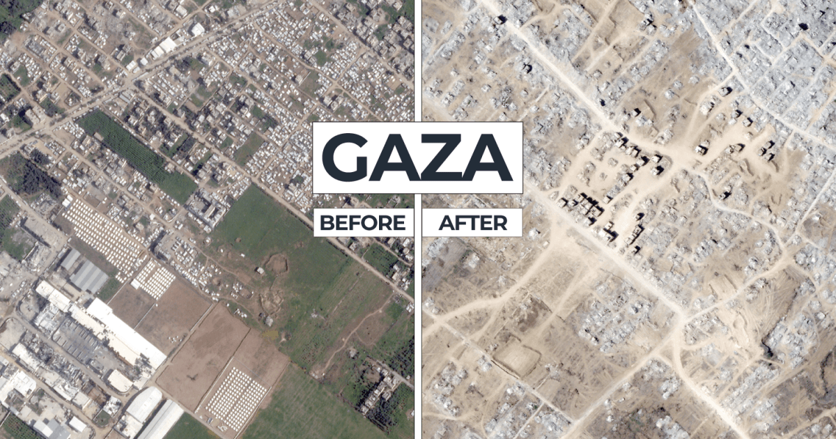
    Satellite imagery from September shows entire neighbourhoods have been flattened and many hospitals, schools, places of worship and homes damaged or destroyed by Israeli attacks.

    Below are before and after images from nine neighbourhoods in northern Gaza:

    Sheikh Radwan

    Over the past few weeks, intensified Israeli military operations have struck Gaza City’s Sheikh Radwan neighbourhood, a densely packed area known for its crowded markets and narrow streets.

    Many residents who had sought refuge there have encountered tanks advancing into the area northwest of the city centre, destroying homes and setting fires in tent encampments.

    Remal

    Gaza City’s Northern and Southern Remal neighbourhoods are home to key landmarks, including al-Shifa Hospital, Gaza’s largest medical facility, and the city’s main seaport.

    Surrounding the hospital were several United Nations compounds, including the UN agency for Palestinian refugees (UNRWA), the Office of the UN Special Coordinator for the Middle East Peace Process (UNSCO) and the UN Development Programme (UNDP).

    Gaza’s top universities – including the Islamic University of Gaza, al-Azhar University-Gaza and Al-Aqsa University, which are just a few hundred metres apart – were also located in Remal.

    In recent weeks, Israeli attacks have destroyed several high-rise residential and office buildings across Remal, including the Mushtaha Tower, al-Ruya building, al-Salam Tower, the Tiba Tower and other multistorey structures.

    Tuffah

    Israeli forces have conducted multiple air strikes and ground operations in Tuffah, targeting residential areas and infrastructure.

    The satellite images below reveal how entire sections of the once vibrant neighbourhood – long known for its bustling markets, schools and community spaces – have been reduced to rubble.

    Sabra

    Israel has destroyed more than 1,000 buildings in the neighbouring Zeitoun and Sabra neighbourhoods of Gaza City since it began its sustained assault on the city on August 6, trapping hundreds of people under rubble, the Palestinian Civil Defence said in August.

    Zeitoun

    Once a thriving, vibrant neighbourhood in Gaza City, Zeitoun, one of the city’s largest and most densely populated areas, was known for its busy markets, olive groves and tight-knit community.

    Today, Zeitoun is unrecognisable. Entire blocks have been flattened, and homes have been reduced to rubble, leaving the neighbourhood devastated and its residents displaced.

    Shujayea

    Shujayea, whose Arabic name means “courage”, is a neighbourhood in eastern Gaza City near the border with Israel.

    It is one of the city’s largest and most densely populated areas, historically a residential and commercial hub with markets, schools and community centres.

    Its location along the eastern edge of Gaza City has made it particularly vulnerable during military operations because it lies close to areas of intense Israeli bombardment and ground incursions.

    Beit Lahiya

    Just north of Gaza City in the North Gaza governorate, Beit Lahiya was once known for its fields of plump, juicy strawberries – locally called “red gold”.

    Israeli bulldozers and heavy machinery have razed these fields, reducing them to dirt.

    Like most of northern Gaza, the humanitarian situation in Beit Lahiya is dire.

    In August, the Integrated Food Security Phase Classification (IPC) hunger monitor declared a famine in northern Gaza as widespread hunger, starvation and displacement affected hundreds of thousands of people.

    The crisis is projected to spread to central and southern Gaza by the end of September, according to the IPC.

    Beit Hanoon

    As of September, Beit Hanoon, located in North Gaza just south of Beit Lahiya and north of Gaza City, remains one of the most devastated areas in Israel’s ongoing war on Gaza.

    The closure of the Beit Hanoon crossing with Israel, known as the Erez crossing in Israel, has further exacerbated the humanitarian crisis, limiting the delivery of aid and hindering the movement of people.

    Jabalia

    The Israeli military has repeatedly hit the Jabalia neighbourhood, including the Jabalia refugee camp, the largest refugee camp in Gaza.

    Established in 1948 for Palestinians displaced during the Nakba, or “catastrophe”, during the creation of Israel, Jabalia is extremely densely populated.

    The camp once housed three UN-run schools, which have been converted into shelters for hundreds of displaced families.


    Source link

  • Before and after satellite images show how Israel has destroyed Gaza City | Israel-Palestine conflict News

    Before and after satellite images show how Israel has destroyed Gaza City | Israel-Palestine conflict News


    Israel is demolishing Gaza City’s high-rise towers, flattening entire blocks that once housed thousands of people.

    The Palestinian Civil Defence said at least 50 multistorey buildings have been destroyed in recent weeks as Israeli forces press their assault on the city, all amid a wave of forced displacements.

    Some neighbourhoods have faced near-total destruction. In Gaza City’s Zeitoun area alone, more than 1,500 homes and buildings have been destroyed since early August, leaving parts of the district with no buildings left standing.

    INTERACTIVE - Gaza neighbourhoods map Israel destroy cms-1757589796
    [Al Jazeera]

    Israel forcing people to move south

    Reporting from Gaza City, Al Jazeera’s Hani Mahmoud said people are making their way from Gaza City to the southern and central areas of the Gaza Strip. However, some people have been coming back because they are unable to find a place to stay.

    The only routes south are Salah al-Din Street and the coastal al-Rashid Street. Salah al-Din is sealed off by snipers while movement along al-Rashid, crowded with displaced families in tents, is deadly.

    There is no safe place in Gaza, including the “humanitarian zone” designated by Israel in the southern coastal area of al-Mawasi.

    INTERACTIVE - Israel pushing people south-1755592754
    Israel is deliberately pushing people south as part of its invasion of northern Gaza [Al Jazeera]

    Satellite imagery from September shows entire neighbourhoods have been flattened and many hospitals, schools, places of worship and homes damaged or destroyed by Israeli attacks.

    Below are before and after images from nine neighbourhoods in northern Gaza:

    Sheikh Radwan

    Over the past few weeks, intensified Israeli military operations have struck Gaza City’s Sheikh Radwan neighbourhood, a densely packed area known for its crowded markets and narrow streets.

    Many residents who had sought refuge there have encountered tanks advancing into the area northwest of the city centre, destroying homes and setting fires in tent encampments.

    Remal

    Gaza City’s Northern and Southern Remal neighbourhoods are home to key landmarks, including al-Shifa Hospital, Gaza’s largest medical facility, and the city’s main seaport.

    Surrounding the hospital were several United Nations compounds, including the UN agency for Palestinian refugees (UNRWA), the Office of the UN Special Coordinator for the Middle East Peace Process (UNSCO) and the UN Development Programme (UNDP).

    Gaza’s top universities – including the Islamic University of Gaza, al-Azhar University-Gaza and Al-Aqsa University, which are just a few hundred metres apart – were also located in Remal.

    In recent weeks, Israeli attacks have destroyed several high-rise residential and office buildings across Remal, including the Mushtaha Tower, al-Ruya building, al-Salam Tower, the Tiba Tower and other multistorey structures.

    Tuffah

    Israeli forces have conducted multiple air strikes and ground operations in Tuffah, targeting residential areas and infrastructure.

    The satellite images below reveal how entire sections of the once vibrant neighbourhood – long known for its bustling markets, schools and community spaces – have been reduced to rubble.

    Sabra

    Israel has destroyed more than 1,000 buildings in the neighbouring Zeitoun and Sabra neighbourhoods of Gaza City since it began its sustained assault on the city on August 6, trapping hundreds of people under rubble, the Palestinian Civil Defence said in August.

    Zeitoun

    Once a thriving, vibrant neighbourhood in Gaza City, Zeitoun, one of the city’s largest and most densely populated areas, was known for its busy markets, olive groves and tight-knit community.

    Today, Zeitoun is unrecognisable. Entire blocks have been flattened, and homes have been reduced to rubble, leaving the neighbourhood devastated and its residents displaced.

    Shujayea

    Shujayea, whose Arabic name means “courage”, is a neighbourhood in eastern Gaza City near the border with Israel.

    It is one of the city’s largest and most densely populated areas, historically a residential and commercial hub with markets, schools and community centres.

    Its location along the eastern edge of Gaza City has made it particularly vulnerable during military operations because it lies close to areas of intense Israeli bombardment and ground incursions.

    Beit Lahiya

    Just north of Gaza City in the North Gaza governorate, Beit Lahiya was once known for its fields of plump, juicy strawberries – locally called “red gold”.

    Israeli bulldozers and heavy machinery have razed these fields, reducing them to dirt.

    Like most of northern Gaza, the humanitarian situation in Beit Lahiya is dire.

    In August, the Integrated Food Security Phase Classification (IPC) hunger monitor declared a famine in northern Gaza as widespread hunger, starvation and displacement affected hundreds of thousands of people.

    The crisis is projected to spread to central and southern Gaza by the end of September, according to the IPC.

    Beit Hanoon

    As of September, Beit Hanoon, located in North Gaza just south of Beit Lahiya and north of Gaza City, remains one of the most devastated areas in Israel’s ongoing war on Gaza.

    The closure of the Beit Hanoon crossing with Israel, known as the Erez crossing in Israel, has further exacerbated the humanitarian crisis, limiting the delivery of aid and hindering the movement of people.

    Jabalia

    The Israeli military has repeatedly hit the Jabalia neighbourhood, including the Jabalia refugee camp, the largest refugee camp in Gaza.

    Established in 1948 for Palestinians displaced during the Nakba, or “catastrophe”, during the creation of Israel, Jabalia is extremely densely populated.

    The camp once housed three UN-run schools, which have been converted into shelters for hundreds of displaced families.


    Source link

  • Before and after satellite images show how Israel has destroyed Gaza City | Israel-Palestine conflict News

    Before and after satellite images show how Israel has destroyed Gaza City | Israel-Palestine conflict News


    Israel is demolishing Gaza City’s high-rise towers, flattening entire blocks that once housed thousands of people.

    The Palestinian Civil Defence said at least 50 multistorey buildings have been destroyed in recent weeks as Israeli forces press their assault on the city, all amid a wave of forced displacements.

    Some neighbourhoods have faced near-total destruction. In Gaza City’s Zeitoun area alone, more than 1,500 homes and buildings have been destroyed since early August, leaving parts of the district with no buildings left standing.

    INTERACTIVE - Gaza neighbourhoods map Israel destroy cms-1757589796
    [Al Jazeera]

    Israel forcing people to move south

    Reporting from Gaza City, Al Jazeera’s Hani Mahmoud said people are making their way from Gaza City to the southern and central areas of the Gaza Strip. However, some people have been coming back because they are unable to find a place to stay.

    The only routes south are Salah al-Din Street and the coastal al-Rashid Street. Salah al-Din is sealed off by snipers while movement along al-Rashid, crowded with displaced families in tents, is deadly.

    There is no safe place in Gaza, including the “humanitarian zone” designated by Israel in the southern coastal area of al-Mawasi.

    INTERACTIVE - Israel pushing people south-1755592754
    Israel is deliberately pushing people south as part of its invasion of northern Gaza [Al Jazeera]

    Satellite imagery from September shows entire neighbourhoods have been flattened and many hospitals, schools, places of worship and homes damaged or destroyed by Israeli attacks.

    Below are before and after images from nine neighbourhoods in northern Gaza:

    Sheikh Radwan

    Over the past few weeks, intensified Israeli military operations have struck Gaza City’s Sheikh Radwan neighbourhood, a densely packed area known for its crowded markets and narrow streets.

    Many residents who had sought refuge there have encountered tanks advancing into the area northwest of the city centre, destroying homes and setting fires in tent encampments.

    Remal

    Gaza City’s Northern and Southern Remal neighbourhoods are home to key landmarks, including al-Shifa Hospital, Gaza’s largest medical facility, and the city’s main seaport.

    Surrounding the hospital were several United Nations compounds, including the UN agency for Palestinian refugees (UNRWA), the Office of the UN Special Coordinator for the Middle East Peace Process (UNSCO) and the UN Development Programme (UNDP).

    Gaza’s top universities – including the Islamic University of Gaza, al-Azhar University-Gaza and Al-Aqsa University, which are just a few hundred metres apart – were also located in Remal.

    In recent weeks, Israeli attacks have destroyed several high-rise residential and office buildings across Remal, including the Mushtaha Tower, al-Ruya building, al-Salam Tower, the Tiba Tower and other multistorey structures.

    Tuffah

    Israeli forces have conducted multiple air strikes and ground operations in Tuffah, targeting residential areas and infrastructure.

    The satellite images below reveal how entire sections of the once vibrant neighbourhood – long known for its bustling markets, schools and community spaces – have been reduced to rubble.

    Sabra

    Israel has destroyed more than 1,000 buildings in the neighbouring Zeitoun and Sabra neighbourhoods of Gaza City since it began its sustained assault on the city on August 6, trapping hundreds of people under rubble, the Palestinian Civil Defence said in August.

    Zeitoun

    Once a thriving, vibrant neighbourhood in Gaza City, Zeitoun, one of the city’s largest and most densely populated areas, was known for its busy markets, olive groves and tight-knit community.

    Today, Zeitoun is unrecognisable. Entire blocks have been flattened, and homes have been reduced to rubble, leaving the neighbourhood devastated and its residents displaced.

    Shujayea

    Shujayea, whose Arabic name means “courage”, is a neighbourhood in eastern Gaza City near the border with Israel.

    It is one of the city’s largest and most densely populated areas, historically a residential and commercial hub with markets, schools and community centres.

    Its location along the eastern edge of Gaza City has made it particularly vulnerable during military operations because it lies close to areas of intense Israeli bombardment and ground incursions.

    Beit Lahiya

    Just north of Gaza City in the North Gaza governorate, Beit Lahiya was once known for its fields of plump, juicy strawberries – locally called “red gold”.

    Israeli bulldozers and heavy machinery have razed these fields, reducing them to dirt.

    Like most of northern Gaza, the humanitarian situation in Beit Lahiya is dire.

    In August, the Integrated Food Security Phase Classification (IPC) hunger monitor declared a famine in northern Gaza as widespread hunger, starvation and displacement affected hundreds of thousands of people.

    The crisis is projected to spread to central and southern Gaza by the end of September, according to the IPC.

    Beit Hanoon

    As of September, Beit Hanoon, located in North Gaza just south of Beit Lahiya and north of Gaza City, remains one of the most devastated areas in Israel’s ongoing war on Gaza.

    The closure of the Beit Hanoon crossing with Israel, known as the Erez crossing in Israel, has further exacerbated the humanitarian crisis, limiting the delivery of aid and hindering the movement of people.

    Jabalia

    The Israeli military has repeatedly hit the Jabalia neighbourhood, including the Jabalia refugee camp, the largest refugee camp in Gaza.

    Established in 1948 for Palestinians displaced during the Nakba, or “catastrophe”, during the creation of Israel, Jabalia is extremely densely populated.

    The camp once housed three UN-run schools, which have been converted into shelters for hundreds of displaced families.


    Source link

  • Before and after satellite images show how Israel has destroyed Gaza City | Israel-Palestine conflict News

    Before and after satellite images show how Israel has destroyed Gaza City | Israel-Palestine conflict News


    Israel is demolishing Gaza City’s high-rise towers, flattening entire blocks that once housed thousands of people.

    The Palestinian Civil Defence said at least 50 multistorey buildings have been destroyed in recent weeks as Israeli forces press their assault on the city, all amid a wave of forced displacements.

    Some neighbourhoods have faced near-total destruction. In Gaza City’s Zeitoun area alone, more than 1,500 homes and buildings have been destroyed since early August, leaving parts of the district with no buildings left standing.

    INTERACTIVE - Gaza neighbourhoods map Israel destroy cms-1757589796
    [Al Jazeera]

    Israel forcing people to move south

    Reporting from Gaza City, Al Jazeera’s Hani Mahmoud said people are making their way from Gaza City to the southern and central areas of the Gaza Strip. However, some people have been coming back because they are unable to find a place to stay.

    The only routes south are Salah al-Din Street and the coastal al-Rashid Street. Salah al-Din is sealed off by snipers while movement along al-Rashid, crowded with displaced families in tents, is deadly.

    There is no safe place in Gaza, including the “humanitarian zone” designated by Israel in the southern coastal area of al-Mawasi.

    INTERACTIVE - Israel pushing people south-1755592754
    Israel is deliberately pushing people south as part of its invasion of northern Gaza [Al Jazeera]

    Satellite imagery from September shows entire neighbourhoods have been flattened and many hospitals, schools, places of worship and homes damaged or destroyed by Israeli attacks.

    Below are before and after images from nine neighbourhoods in northern Gaza:

    Sheikh Radwan

    Over the past few weeks, intensified Israeli military operations have struck Gaza City’s Sheikh Radwan neighbourhood, a densely packed area known for its crowded markets and narrow streets.

    Many residents who had sought refuge there have encountered tanks advancing into the area northwest of the city centre, destroying homes and setting fires in tent encampments.

    Remal

    Gaza City’s Northern and Southern Remal neighbourhoods are home to key landmarks, including al-Shifa Hospital, Gaza’s largest medical facility, and the city’s main seaport.

    Surrounding the hospital were several United Nations compounds, including the UN agency for Palestinian refugees (UNRWA), the Office of the UN Special Coordinator for the Middle East Peace Process (UNSCO) and the UN Development Programme (UNDP).

    Gaza’s top universities – including the Islamic University of Gaza, al-Azhar University-Gaza and Al-Aqsa University, which are just a few hundred metres apart – were also located in Remal.

    In recent weeks, Israeli attacks have destroyed several high-rise residential and office buildings across Remal, including the Mushtaha Tower, al-Ruya building, al-Salam Tower, the Tiba Tower and other multistorey structures.

    Tuffah

    Israeli forces have conducted multiple air strikes and ground operations in Tuffah, targeting residential areas and infrastructure.

    The satellite images below reveal how entire sections of the once vibrant neighbourhood – long known for its bustling markets, schools and community spaces – have been reduced to rubble.

    Sabra

    Israel has destroyed more than 1,000 buildings in the neighbouring Zeitoun and Sabra neighbourhoods of Gaza City since it began its sustained assault on the city on August 6, trapping hundreds of people under rubble, the Palestinian Civil Defence said in August.

    Zeitoun

    Once a thriving, vibrant neighbourhood in Gaza City, Zeitoun, one of the city’s largest and most densely populated areas, was known for its busy markets, olive groves and tight-knit community.

    Today, Zeitoun is unrecognisable. Entire blocks have been flattened, and homes have been reduced to rubble, leaving the neighbourhood devastated and its residents displaced.

    Shujayea

    Shujayea, whose Arabic name means “courage”, is a neighbourhood in eastern Gaza City near the border with Israel.

    It is one of the city’s largest and most densely populated areas, historically a residential and commercial hub with markets, schools and community centres.

    Its location along the eastern edge of Gaza City has made it particularly vulnerable during military operations because it lies close to areas of intense Israeli bombardment and ground incursions.

    Beit Lahiya

    Just north of Gaza City in the North Gaza governorate, Beit Lahiya was once known for its fields of plump, juicy strawberries – locally called “red gold”.

    Israeli bulldozers and heavy machinery have razed these fields, reducing them to dirt.

    Like most of northern Gaza, the humanitarian situation in Beit Lahiya is dire.

    In August, the Integrated Food Security Phase Classification (IPC) hunger monitor declared a famine in northern Gaza as widespread hunger, starvation and displacement affected hundreds of thousands of people.

    The crisis is projected to spread to central and southern Gaza by the end of September, according to the IPC.

    Beit Hanoon

    As of September, Beit Hanoon, located in North Gaza just south of Beit Lahiya and north of Gaza City, remains one of the most devastated areas in Israel’s ongoing war on Gaza.

    The closure of the Beit Hanoon crossing with Israel, known as the Erez crossing in Israel, has further exacerbated the humanitarian crisis, limiting the delivery of aid and hindering the movement of people.

    Jabalia

    The Israeli military has repeatedly hit the Jabalia neighbourhood, including the Jabalia refugee camp, the largest refugee camp in Gaza.

    Established in 1948 for Palestinians displaced during the Nakba, or “catastrophe”, during the creation of Israel, Jabalia is extremely densely populated.

    The camp once housed three UN-run schools, which have been converted into shelters for hundreds of displaced families.


    Source link

  • Before and after satellite images show how Israel has destroyed Gaza City | Israel-Palestine conflict News

    Before and after satellite images show how Israel has destroyed Gaza City | Israel-Palestine conflict News


    Israel is demolishing Gaza City’s high-rise towers, flattening entire blocks that once housed thousands of people.

    The Palestinian Civil Defence said at least 50 multistorey buildings have been destroyed in recent weeks as Israeli forces press their assault on the city, all amid a wave of forced displacements.

    Some neighbourhoods have faced near-total destruction. In Gaza City’s Zeitoun area alone, more than 1,500 homes and buildings have been destroyed since early August, leaving parts of the district with no buildings left standing.

    INTERACTIVE - Gaza neighbourhoods map Israel destroy cms-1757589796
    [Al Jazeera]

    Israel forcing people to move south

    Reporting from Gaza City, Al Jazeera’s Hani Mahmoud said people are making their way from Gaza City to the southern and central areas of the Gaza Strip. However, some people have been coming back because they are unable to find a place to stay.

    The only routes south are Salah al-Din Street and the coastal al-Rashid Street. Salah al-Din is sealed off by snipers while movement along al-Rashid, crowded with displaced families in tents, is deadly.

    There is no safe place in Gaza, including the “humanitarian zone” designated by Israel in the southern coastal area of al-Mawasi.

    INTERACTIVE - Israel pushing people south-1755592754
    Israel is deliberately pushing people south as part of its invasion of northern Gaza [Al Jazeera]

    Satellite imagery from September shows entire neighbourhoods have been flattened and many hospitals, schools, places of worship and homes damaged or destroyed by Israeli attacks.

    Below are before and after images from nine neighbourhoods in northern Gaza:

    Sheikh Radwan

    Over the past few weeks, intensified Israeli military operations have struck Gaza City’s Sheikh Radwan neighbourhood, a densely packed area known for its crowded markets and narrow streets.

    Many residents who had sought refuge there have encountered tanks advancing into the area northwest of the city centre, destroying homes and setting fires in tent encampments.

    Remal

    Gaza City’s Northern and Southern Remal neighbourhoods are home to key landmarks, including al-Shifa Hospital, Gaza’s largest medical facility, and the city’s main seaport.

    Surrounding the hospital were several United Nations compounds, including the UN agency for Palestinian refugees (UNRWA), the Office of the UN Special Coordinator for the Middle East Peace Process (UNSCO) and the UN Development Programme (UNDP).

    Gaza’s top universities – including the Islamic University of Gaza, al-Azhar University-Gaza and Al-Aqsa University, which are just a few hundred metres apart – were also located in Remal.

    In recent weeks, Israeli attacks have destroyed several high-rise residential and office buildings across Remal, including the Mushtaha Tower, al-Ruya building, al-Salam Tower, the Tiba Tower and other multistorey structures.

    Tuffah

    Israeli forces have conducted multiple air strikes and ground operations in Tuffah, targeting residential areas and infrastructure.

    The satellite images below reveal how entire sections of the once vibrant neighbourhood – long known for its bustling markets, schools and community spaces – have been reduced to rubble.

    Sabra

    Israel has destroyed more than 1,000 buildings in the neighbouring Zeitoun and Sabra neighbourhoods of Gaza City since it began its sustained assault on the city on August 6, trapping hundreds of people under rubble, the Palestinian Civil Defence said in August.

    Zeitoun

    Once a thriving, vibrant neighbourhood in Gaza City, Zeitoun, one of the city’s largest and most densely populated areas, was known for its busy markets, olive groves and tight-knit community.

    Today, Zeitoun is unrecognisable. Entire blocks have been flattened, and homes have been reduced to rubble, leaving the neighbourhood devastated and its residents displaced.

    Shujayea

    Shujayea, whose Arabic name means “courage”, is a neighbourhood in eastern Gaza City near the border with Israel.

    It is one of the city’s largest and most densely populated areas, historically a residential and commercial hub with markets, schools and community centres.

    Its location along the eastern edge of Gaza City has made it particularly vulnerable during military operations because it lies close to areas of intense Israeli bombardment and ground incursions.

    Beit Lahiya

    Just north of Gaza City in the North Gaza governorate, Beit Lahiya was once known for its fields of plump, juicy strawberries – locally called “red gold”.

    Israeli bulldozers and heavy machinery have razed these fields, reducing them to dirt.

    Like most of northern Gaza, the humanitarian situation in Beit Lahiya is dire.

    In August, the Integrated Food Security Phase Classification (IPC) hunger monitor declared a famine in northern Gaza as widespread hunger, starvation and displacement affected hundreds of thousands of people.

    The crisis is projected to spread to central and southern Gaza by the end of September, according to the IPC.

    Beit Hanoon

    As of September, Beit Hanoon, located in North Gaza just south of Beit Lahiya and north of Gaza City, remains one of the most devastated areas in Israel’s ongoing war on Gaza.

    The closure of the Beit Hanoon crossing with Israel, known as the Erez crossing in Israel, has further exacerbated the humanitarian crisis, limiting the delivery of aid and hindering the movement of people.

    Jabalia

    The Israeli military has repeatedly hit the Jabalia neighbourhood, including the Jabalia refugee camp, the largest refugee camp in Gaza.

    Established in 1948 for Palestinians displaced during the Nakba, or “catastrophe”, during the creation of Israel, Jabalia is extremely densely populated.

    The camp once housed three UN-run schools, which have been converted into shelters for hundreds of displaced families.


    Source link

  • Before and after satellite images show how Israel has destroyed Gaza City | Israel-Palestine conflict News

    Before and after satellite images show how Israel has destroyed Gaza City | Israel-Palestine conflict News


    Israel is demolishing Gaza City’s high-rise towers, flattening entire blocks that once housed thousands of people.

    The Palestinian Civil Defence said at least 50 multistorey buildings have been destroyed in recent weeks as Israeli forces press their assault on the city, all amid a wave of forced displacements.

    Some neighbourhoods have faced near-total destruction. In Gaza City’s Zeitoun area alone, more than 1,500 homes and buildings have been destroyed since early August, leaving parts of the district with no buildings left standing.

    INTERACTIVE - Gaza neighbourhoods map Israel destroy cms-1757589796
    [Al Jazeera]

    Israel forcing people to move south

    Reporting from Gaza City, Al Jazeera’s Hani Mahmoud said people are making their way from Gaza City to the southern and central areas of the Gaza Strip. However, some people have been coming back because they are unable to find a place to stay.

    The only routes south are Salah al-Din Street and the coastal al-Rashid Street. Salah al-Din is sealed off by snipers while movement along al-Rashid, crowded with displaced families in tents, is deadly.

    There is no safe place in Gaza, including the “humanitarian zone” designated by Israel in the southern coastal area of al-Mawasi.

    INTERACTIVE - Israel pushing people south-1755592754
    Israel is deliberately pushing people south as part of its invasion of northern Gaza [Al Jazeera]

    Satellite imagery from September shows entire neighbourhoods have been flattened and many hospitals, schools, places of worship and homes damaged or destroyed by Israeli attacks.

    Below are before and after images from nine neighbourhoods in northern Gaza:

    Sheikh Radwan

    Over the past few weeks, intensified Israeli military operations have struck Gaza City’s Sheikh Radwan neighbourhood, a densely packed area known for its crowded markets and narrow streets.

    Many residents who had sought refuge there have encountered tanks advancing into the area northwest of the city centre, destroying homes and setting fires in tent encampments.

    Remal

    Gaza City’s Northern and Southern Remal neighbourhoods are home to key landmarks, including al-Shifa Hospital, Gaza’s largest medical facility, and the city’s main seaport.

    Surrounding the hospital were several United Nations compounds, including the UN agency for Palestinian refugees (UNRWA), the Office of the UN Special Coordinator for the Middle East Peace Process (UNSCO) and the UN Development Programme (UNDP).

    Gaza’s top universities – including the Islamic University of Gaza, al-Azhar University-Gaza and Al-Aqsa University, which are just a few hundred metres apart – were also located in Remal.

    In recent weeks, Israeli attacks have destroyed several high-rise residential and office buildings across Remal, including the Mushtaha Tower, al-Ruya building, al-Salam Tower, the Tiba Tower and other multistorey structures.

    Tuffah

    Israeli forces have conducted multiple air strikes and ground operations in Tuffah, targeting residential areas and infrastructure.

    The satellite images below reveal how entire sections of the once vibrant neighbourhood – long known for its bustling markets, schools and community spaces – have been reduced to rubble.

    Sabra

    Israel has destroyed more than 1,000 buildings in the neighbouring Zeitoun and Sabra neighbourhoods of Gaza City since it began its sustained assault on the city on August 6, trapping hundreds of people under rubble, the Palestinian Civil Defence said in August.

    Zeitoun

    Once a thriving, vibrant neighbourhood in Gaza City, Zeitoun, one of the city’s largest and most densely populated areas, was known for its busy markets, olive groves and tight-knit community.

    Today, Zeitoun is unrecognisable. Entire blocks have been flattened, and homes have been reduced to rubble, leaving the neighbourhood devastated and its residents displaced.

    Shujayea

    Shujayea, whose Arabic name means “courage”, is a neighbourhood in eastern Gaza City near the border with Israel.

    It is one of the city’s largest and most densely populated areas, historically a residential and commercial hub with markets, schools and community centres.

    Its location along the eastern edge of Gaza City has made it particularly vulnerable during military operations because it lies close to areas of intense Israeli bombardment and ground incursions.

    Beit Lahiya

    Just north of Gaza City in the North Gaza governorate, Beit Lahiya was once known for its fields of plump, juicy strawberries – locally called “red gold”.

    Israeli bulldozers and heavy machinery have razed these fields, reducing them to dirt.

    Like most of northern Gaza, the humanitarian situation in Beit Lahiya is dire.

    In August, the Integrated Food Security Phase Classification (IPC) hunger monitor declared a famine in northern Gaza as widespread hunger, starvation and displacement affected hundreds of thousands of people.

    The crisis is projected to spread to central and southern Gaza by the end of September, according to the IPC.

    Beit Hanoon

    As of September, Beit Hanoon, located in North Gaza just south of Beit Lahiya and north of Gaza City, remains one of the most devastated areas in Israel’s ongoing war on Gaza.

    The closure of the Beit Hanoon crossing with Israel, known as the Erez crossing in Israel, has further exacerbated the humanitarian crisis, limiting the delivery of aid and hindering the movement of people.

    Jabalia

    The Israeli military has repeatedly hit the Jabalia neighbourhood, including the Jabalia refugee camp, the largest refugee camp in Gaza.

    Established in 1948 for Palestinians displaced during the Nakba, or “catastrophe”, during the creation of Israel, Jabalia is extremely densely populated.

    The camp once housed three UN-run schools, which have been converted into shelters for hundreds of displaced families.


    Source link

  • Russia-Belarus military drills worry their Western neighbors

    Russia-Belarus military drills worry their Western neighbors


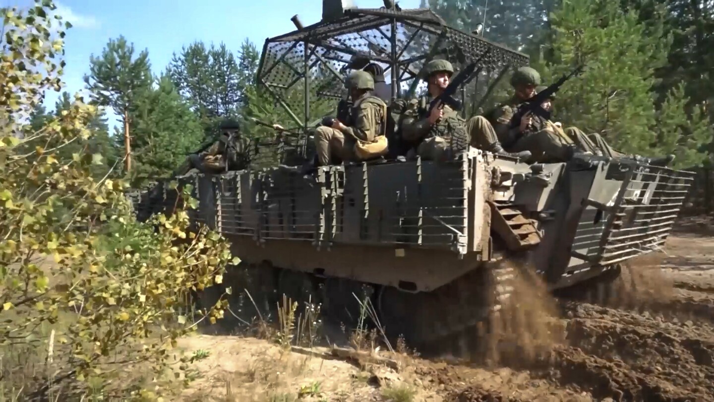
    Russia and Belarus on Friday launched a long-planned joint military exercise involving thousands of troops that has raised concern in the West.

    The exercises, dubbed “Zapad 2025,” or “West 2025,” are held in Belarus and Russia and will last through Tuesday. They are intended to showcase close defense ties between Moscow and Minsk, as well as Russia’s military might as it fights its 3½-year-old war in neighboring Ukraine.

    The maneuvers follow an incursion of Russian drones into Polish airspace earlier this week which fueled longstanding fears that the hostilities in Ukraine could trigger a wider conflict. The Russian military said it wasn’t targeting Poland, and Belarus suggested drones veered off course. But European leaders described it as a deliberate provocation, forcing NATO allies to confront a potential threat in its airspace for the first time.

    The Russia-Belarus exercises also have drawn worries in Kyiv and its Western allies of Latvia, Lithuania and Poland, which border Belarus. When Russian President Vladimir Putin sent troops rolling into Ukraine on Feb. 24, 2022, many of them crossed from Belarus following joint drills days before the attack.

    Belarusian defense officials initially said about 13,000 troops would participate in the exercise that was to take place near its western border. In May, however, its Defense Ministry said the number would be cut nearly in half, and that the main maneuvers would take place deeper inside the country.

    In Moscow, the Defense Ministry said Friday that parts of the exercise will be held on Russian territory and on the Baltic and the Barents seas.

    Last month, Defense Minister Viktor Khrenin said most of the drills will happen around the city of Barysaw, about 74 kilometers (46 miles) northeast of Minsk, although some “small units will carry out practical tasks to repel a hypothetical enemy” in areas close to the border with Poland and Lithuania.

    Khrenin noted that the troops will practice “planning the use of” Russian nuclear weapons and the new nuclear-capable Oreshnik intermediate range missiles that Moscow has promised to station in Belarus.

    In December, Russia and Belarus signed a pact giving Moscow’s security guarantees to its ally, including the possible use of Russian nuclear weapons to help repel any aggression.

    Belarus’ President Alexander Lukashenko has allowed Russia to deploy some of its tactical nuclear weapons to his country. Lukashenko also has proposed to host Russia’s latest Oreshnik intermediate-range ballistic missile that Moscow used for the first time in November against Ukraine.

    Putin has said that Oreshnik missiles could be deployed to Belarus in the second half of 2025. He said they will remain under Russian control but that Moscow will allow Minsk to select targets.

    Belarus sent formal invitations to all member states of the Organization for Security and Cooperation in Europe and nine countries with NATO military attaches in Minsk to monitor the drills.

    Lukashenko, who has ruled Belarus with an iron hand for over 30 years, recently signaled willingness to mend his relationship with the West, which has been severely strained for years over his brutal crackdown on dissent and his support for Russia’s war in Ukraine.

    The past year has seen regular releases of political prisoners and public calls for a rapprochement with the West. Last month, Lukashenko spoke by phone with Trump, who called him a “highly respected President” in a social media post, a stark contrast from other Western leaders, who have largely shunned the Belarusian leader.

    On Thursday, Belarus freed 52 political prisoners as part of a deal brokered by the United States, which lifted some sanctions on the country’s national airline.

    window.fbAsyncInit = function() {
    FB.init({

    appId : ‘870613919693099’,

    xfbml : true,
    version : ‘v2.9’
    });
    };

    (function(d, s, id){
    var js, fjs = d.getElementsByTagName(s)[0];
    if (d.getElementById(id)) {return;}
    js = d.createElement(s); js.id = id;
    js.src = “https://connect.facebook.net/en_US/sdk.js”;
    fjs.parentNode.insertBefore(js, fjs);
    }(document, ‘script’, ‘facebook-jssdk’));


    Source link